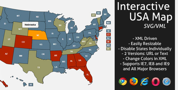
Interactive US Mapwith State Abbreviations & Customization
Discover our feature-rich, responsive HTML5 US map template. Easily customize colors, add interactive pins, and control state visibility directly within your XML file. Perfect for websites needing engaging geographical data visualization.
- Responsive Design: Automatically adapts to any screen size, or disable it for fixed layouts.
- Add Interactive Pins: Place custom markers on any state for enhanced user engagement.
- Modern & Accessible: Built with JavaScript (Raphael) – no Flash required. Fully compatible with iPad and iPhone.
- XML Customization: Change all colors, resize the map, and define state names directly in XML.
- Two Navigation Options: Choose between URL navigation or displaying text when a state is clicked.
- State Control: Activate or deactivate individual states independently (e.g., Utah deactivated in preview).
- Included Features: State abbreviations, optional text area size and padding, full documentation.
Key Updates
Stay current with our latest improvements:
- V2.0 (Oct 18, 2013): Added responsive option & pin functionality. Fixed IE hover issue. Cleaned code.
- V1.3 (Feb 18, 2013): Enhanced jQuery support & added example with text below the map.
- V1.2 (Nov 20, 2012): Introduced state abbreviations & thumbnail navigation for smaller states. Detailed update instructions provided.
Included Files
Get everything you need for immediate implementation:
- Interactive HTML5 US Map Template
- Full Documentation & Help Files
- Two Navigation Version Options
- XML Configuration Files